
Select Category


Brands
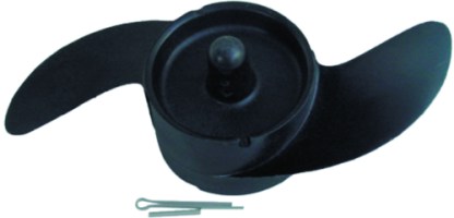
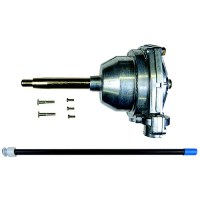
Navigator Replacement Power Prop Fits All Navigator Models - 481-658302 - 481-658302F1
Navigator Replacement Power Prop Propeller

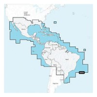
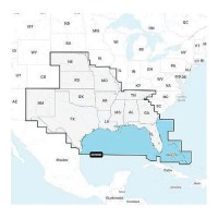
Navionics 010C136430 Navionics+ Cartography, Mexico, Caribbean To Brazil - 010-C1364-30 - 155-010C136430F1
THE NAVIONICS SUBSCRIPTION: A one-year subscription to Daily Updates and advanced features is included when you purchase any Navionics+ mapping solution. After a year, you can renew at a discounted price.CHARTS AND UPDATES:Nautical Chart - Comprehensive charts are derived from multiple official, government and private sources, displayed in a familiar look and feel.SonarChart HD Bathymetry - Innovative 1' (0.5 m) bathymetry charts are created by using Navionics proprietary systems that augment existing content with sonar data contributed by the boating community.Community Edits - Get useful local knowledge from edits made by users of the Navionics Boating app on your compatible smart device.Daily Updates - Up to 5,000 daily updates to our charts give you the most accurate, most current data availableInland Content: 42,000+ lakes (varies by coverage area)ADVANCED FEATURES:Dock-to-dock Route Guidance - Start your trip with a suggested dock-to-dock route.Advanced Map Options - Customize your view to focus on the details that matter most.Plotter Sync - Transfer routes and markers, update chart layers and more - between your compatible chartplotter and the Boating app.SonarChart Live Mapping Feature - Watch new HD depth maps develop in real time as your boat moves through the water. Visit Navionics website for full feature list, coverage details and compatibility of Navionics+ content and features with your GPS chartplotter. **NOT COMPATIBLE with GARMIN GPS chartplotters**
Navionics 010C136440 Platinum+ Cartography, Mexico, Caribbean To Brazil - 010-C1364-40 - 155-010C136440F1
THE NAVIONICS SUBSCRIPTION: A one-year subscription to Daily Updates and advanced features is included when you purchase any new Navionics Platinum+ mapping solution. After a year, you can renew at a discounted price CHARTS AND UPDATES:Nautical Chart - Comprehensive charts are derived from multiple official, government and private sources, displayed in a familiar look and feelSonarChart HD Bathymetry - Innovative 1' (0.5 m) bathymetry charts are created by using Navionics proprietary systems that augment existing content with sonar data contributed by the boating communityCommunity Edits - Get useful local knowledge from edits made by users of the Navionics Boating app on your compatible smart device.Daily Updates - Up to 5,000 daily updates to our charts give you the most accurate, most current Navionics data availableInland Content: 42,000+ lakes (varies by coverage area) ADVANCED FEATURES:Dock-to-dock Route Guidance - Start your trip with a suggested pathSonarChart Live Mapping Feature - Watch new HD depth maps develop in real time as your boat moves through the waterAdvanced Map Options - Customize your view to focus on the details that matter mostPlotter Sync - Transfer routes and markers, update chart layers and more - between your compatible chartplotter and the Boating app OVERLAYS:Relief Shading - Get an easy-to-interpret, clearer view of bottom structure. Check coverageSatellite Imagery with SonarChart Shading Overlay - Experience an enhanced awareness above and below the waterline. Check coverageSonar Imagery - View bottom hardness clearly and in contrasting color PLATINUM+ ADDITIONAL VIEWING OPTIONS:3D View - Adjust the perspective of your chart view to highlight key features and enhance awarenessAerial Photos - Get a better sense of your surroundingsVisit Navionics website for full feature list, coverage details and compatibility of Platinum+ content and features with your GPS chartplotter.**NOT COMPATIBLE with GARMIN GPS chartplotters**
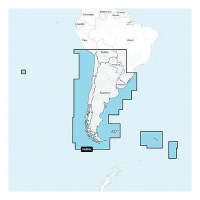
Navionics 010C136530 Navionics+ Cartography, Chile, Argentina & Easter Island - 010-C1365-30 - 155-010C136530F1
THE NAVIONICS SUBSCRIPTION: A one-year subscription to Daily Updates and advanced features is included when you purchase any Navionics+ mapping solution. After a year, you can renew at a discounted price.CHARTS AND UPDATES:Nautical Chart - Comprehensive charts are derived from multiple official, government and private sources, displayed in a familiar look and feel.SonarChart HD Bathymetry - Innovative 1' (0.5 m) bathymetry charts are created by using Navionics proprietary systems that augment existing content with sonar data contributed by the boating community.Community Edits - Get useful local knowledge from edits made by users of the Navionics Boating app on your compatible smart device.Daily Updates - Up to 5,000 daily updates to our charts give you the most accurate, most current data availableInland Content: 42,000+ lakes (varies by coverage area)ADVANCED FEATURES:Dock-to-dock Route Guidance - Start your trip with a suggested dock-to-dock route.Advanced Map Options - Customize your view to focus on the details that matter most.Plotter Sync - Transfer routes and markers, update chart layers and more - between your compatible chartplotter and the Boating app.SonarChart Live Mapping Feature - Watch new HD depth maps develop in real time as your boat moves through the water. Visit Navionics website for full feature list, coverage details and compatibility of Navionics+ content and features with your GPS chartplotter. **NOT COMPATIBLE with GARMIN GPS chartplotters**
Navionics 010C136540 Platinum+ Cartography, Chile, Argentina & Easter Island - 010-C1365-40 - 155-010C136540F1
THE NAVIONICS SUBSCRIPTION: A one-year subscription to Daily Updates and advanced features is included when you purchase any new Navionics Platinum+ mapping solution. After a year, you can renew at a discounted price CHARTS AND UPDATES:Nautical Chart - Comprehensive charts are derived from multiple official, government and private sources, displayed in a familiar look and feelSonarChart HD Bathymetry - Innovative 1' (0.5 m) bathymetry charts are created by using Navionics proprietary systems that augment existing content with sonar data contributed by the boating communityCommunity Edits - Get useful local knowledge from edits made by users of the Navionics Boating app on your compatible smart device.Daily Updates - Up to 5,000 daily updates to our charts give you the most accurate, most current Navionics data availableInland Content: 42,000+ lakes (varies by coverage area) ADVANCED FEATURES:Dock-to-dock Route Guidance - Start your trip with a suggested pathSonarChart Live Mapping Feature - Watch new HD depth maps develop in real time as your boat moves through the waterAdvanced Map Options - Customize your view to focus on the details that matter mostPlotter Sync - Transfer routes and markers, update chart layers and more - between your compatible chartplotter and the Boating app OVERLAYS:Relief Shading - Get an easy-to-interpret, clearer view of bottom structure. Check coverageSatellite Imagery with SonarChart Shading Overlay - Experience an enhanced awareness above and below the waterline. Check coverageSonar Imagery - View bottom hardness clearly and in contrasting color PLATINUM+ ADDITIONAL VIEWING OPTIONS:3D View - Adjust the perspective of your chart view to highlight key features and enhance awarenessAerial Photos - Get a better sense of your surroundingsVisit Navionics website for full feature list, coverage details and compatibility of Platinum+ content and features with your GPS chartplotter.**NOT COMPATIBLE with GARMIN GPS chartplotters**
Navionics 010C136630 Navionics+ Cartography, U.S. & Coastal Canada - 010-C1366-30 - 155-010C136630F1
THE NAVIONICS SUBSCRIPTION: A one-year subscription to Daily Updates and advanced features is included when you purchase any Navionics+ mapping solution. After a year, you can renew at a discounted price.CHARTS AND UPDATES:Nautical Chart - Comprehensive charts are derived from multiple official, government and private sources, displayed in a familiar look and feel.SonarChart HD Bathymetry - Innovative 1' (0.5 m) bathymetry charts are created by using Navionics proprietary systems that augment existing content with sonar data contributed by the boating community.Community Edits - Get useful local knowledge from edits made by users of the Navionics Boating app on your compatible smart device.Daily Updates - Up to 5,000 daily updates to our charts give you the most accurate, most current data availableInland Content: 42,000+ lakes (varies by coverage area)ADVANCED FEATURES:Dock-to-dock Route Guidance - Start your trip with a suggested dock-to-dock route.Advanced Map Options - Customize your view to focus on the details that matter most.Plotter Sync - Transfer routes and markers, update chart layers and more - between your compatible chartplotter and the Boating app.SonarChart Live Mapping Feature - Watch new HD depth maps develop in real time as your boat moves through the water. Visit Navionics website for full feature list, coverage details and compatibility of Navionics+ content and features with your GPS chartplotter. **NOT COMPATIBLE with GARMIN GPS chartplotters**
Navionics 010C136830 Navionics+ Cartography, U.S. North - 010-C1368-30 - 155-010C136830F1
THE NAVIONICS SUBSCRIPTION: A one-year subscription to Daily Updates and advanced features is included when you purchase any Navionics+ mapping solution. After a year, you can renew at a discounted price.CHARTS AND UPDATES:Nautical Chart - Comprehensive charts are derived from multiple official, government and private sources, displayed in a familiar look and feel.SonarChart HD Bathymetry - Innovative 1' (0.5 m) bathymetry charts are created by using Navionics proprietary systems that augment existing content with sonar data contributed by the boating community.Community Edits - Get useful local knowledge from edits made by users of the Navionics Boating app on your compatible smart device.Daily Updates - Up to 5,000 daily updates to our charts give you the most accurate, most current data availableInland Content: 42,000+ lakes (varies by coverage area)ADVANCED FEATURES:Dock-to-dock Route Guidance - Start your trip with a suggested dock-to-dock route.Advanced Map Options - Customize your view to focus on the details that matter most.Plotter Sync - Transfer routes and markers, update chart layers and more - between your compatible chartplotter and the Boating app.SonarChart Live Mapping Feature - Watch new HD depth maps develop in real time as your boat moves through the water. Visit Navionics website for full feature list, coverage details and compatibility of Navionics+ content and features with your GPS chartplotter. **NOT COMPATIBLE with GARMIN GPS chartplotters**

Navionics 010C136840 Platinum+ Cartography, U.S. North - 010-C1368-40 - 155-010C136840F1
THE NAVIONICS SUBSCRIPTION: A one-year subscription to Daily Updates and advanced features is included when you purchase any new Navionics Platinum+ mapping solution. After a year, you can renew at a discounted price CHARTS AND UPDATES:Nautical Chart - Comprehensive charts are derived from multiple official, government and private sources, displayed in a familiar look and feelSonarChart HD Bathymetry - Innovative 1' (0.5 m) bathymetry charts are created by using Navionics proprietary systems that augment existing content with sonar data contributed by the boating communityCommunity Edits - Get useful local knowledge from edits made by users of the Navionics Boating app on your compatible smart device.Daily Updates - Up to 5,000 daily updates to our charts give you the most accurate, most current Navionics data availableInland Content: 42,000+ lakes (varies by coverage area) ADVANCED FEATURES:Dock-to-dock Route Guidance - Start your trip with a suggested pathSonarChart Live Mapping Feature - Watch new HD depth maps develop in real time as your boat moves through the waterAdvanced Map Options - Customize your view to focus on the details that matter mostPlotter Sync - Transfer routes and markers, update chart layers and more - between your compatible chartplotter and the Boating app OVERLAYS:Relief Shading - Get an easy-to-interpret, clearer view of bottom structure. Check coverageSatellite Imagery with SonarChart Shading Overlay - Experience an enhanced awareness above and below the waterline. Check coverageSonar Imagery - View bottom hardness clearly and in contrasting color PLATINUM+ ADDITIONAL VIEWING OPTIONS:3D View - Adjust the perspective of your chart view to highlight key features and enhance awarenessAerial Photos - Get a better sense of your surroundingsVisit Navionics website for full feature list, coverage details and compatibility of Platinum+ content and features with your GPS chartplotter.**NOT COMPATIBLE with GARMIN GPS chartplotters**
Navionics 010C136930 Navionics+ Cartography, U.S. South - 010-C1369-30 - 155-010C136930F1
THE NAVIONICS SUBSCRIPTION: A one-year subscription to Daily Updates and advanced features is included when you purchase any Navionics+ mapping solution. After a year, you can renew at a discounted price.CHARTS AND UPDATES:Nautical Chart - Comprehensive charts are derived from multiple official, government and private sources, displayed in a familiar look and feel.SonarChart HD Bathymetry - Innovative 1' (0.5 m) bathymetry charts are created by using Navionics proprietary systems that augment existing content with sonar data contributed by the boating community.Community Edits - Get useful local knowledge from edits made by users of the Navionics Boating app on your compatible smart device.Daily Updates - Up to 5,000 daily updates to our charts give you the most accurate, most current data availableInland Content: 42,000+ lakes (varies by coverage area)ADVANCED FEATURES:Dock-to-dock Route Guidance - Start your trip with a suggested dock-to-dock route.Advanced Map Options - Customize your view to focus on the details that matter most.Plotter Sync - Transfer routes and markers, update chart layers and more - between your compatible chartplotter and the Boating app.SonarChart Live Mapping Feature - Watch new HD depth maps develop in real time as your boat moves through the water. Visit Navionics website for full feature list, coverage details and compatibility of Navionics+ content and features with your GPS chartplotter. **NOT COMPATIBLE with GARMIN GPS chartplotters**
Navionics 010C136940 Platinum+ Cartography, U.S. South - 010-C1369-40 - 155-010C136940F1
THE NAVIONICS SUBSCRIPTION: A one-year subscription to Daily Updates and advanced features is included when you purchase any new Navionics Platinum+ mapping solution. After a year, you can renew at a discounted price CHARTS AND UPDATES:Nautical Chart - Comprehensive charts are derived from multiple official, government and private sources, displayed in a familiar look and feelSonarChart HD Bathymetry - Innovative 1' (0.5 m) bathymetry charts are created by using Navionics proprietary systems that augment existing content with sonar data contributed by the boating communityCommunity Edits - Get useful local knowledge from edits made by users of the Navionics Boating app on your compatible smart device.Daily Updates - Up to 5,000 daily updates to our charts give you the most accurate, most current Navionics data availableInland Content: 42,000+ lakes (varies by coverage area) ADVANCED FEATURES:Dock-to-dock Route Guidance - Start your trip with a suggested pathSonarChart Live Mapping Feature - Watch new HD depth maps develop in real time as your boat moves through the waterAdvanced Map Options - Customize your view to focus on the details that matter mostPlotter Sync - Transfer routes and markers, update chart layers and more - between your compatible chartplotter and the Boating app OVERLAYS:Relief Shading - Get an easy-to-interpret, clearer view of bottom structure. Check coverageSatellite Imagery with SonarChart Shading Overlay - Experience an enhanced awareness above and below the waterline. Check coverageSonar Imagery - View bottom hardness clearly and in contrasting color PLATINUM+ ADDITIONAL VIEWING OPTIONS:3D View - Adjust the perspective of your chart view to highlight key features and enhance awarenessAerial Photos - Get a better sense of your surroundingsVisit Navionics website for full feature list, coverage details and compatibility of Platinum+ content and features with your GPS chartplotter.**NOT COMPATIBLE with GARMIN GPS chartplotters**
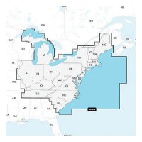
Navionics 010C137030 Navionics+ Cartography, U.S. East - 010-C1370-30 - 155-010C137030F1
THE NAVIONICS SUBSCRIPTION: A one-year subscription to Daily Updates and advanced features is included when you purchase any Navionics+ mapping solution. After a year, you can renew at a discounted price.CHARTS AND UPDATES:Nautical Chart - Comprehensive charts are derived from multiple official, government and private sources, displayed in a familiar look and feel.SonarChart HD Bathymetry - Innovative 1' (0.5 m) bathymetry charts are created by using Navionics proprietary systems that augment existing content with sonar data contributed by the boating community.Community Edits - Get useful local knowledge from edits made by users of the Navionics Boating app on your compatible smart device.Daily Updates - Up to 5,000 daily updates to our charts give you the most accurate, most current data availableInland Content: 42,000+ lakes (varies by coverage area)ADVANCED FEATURES:Dock-to-dock Route Guidance - Start your trip with a suggested dock-to-dock route.Advanced Map Options - Customize your view to focus on the details that matter most.Plotter Sync - Transfer routes and markers, update chart layers and more - between your compatible chartplotter and the Boating app.SonarChart Live Mapping Feature - Watch new HD depth maps develop in real time as your boat moves through the water. Visit Navionics website for full feature list, coverage details and compatibility of Navionics+ content and features with your GPS chartplotter. **NOT COMPATIBLE with GARMIN GPS chartplotters**
Navionics 010C137040 Platinum+ Cartography, U.S. East - 010-C1370-40 - 155-010C137040F1
THE NAVIONICS SUBSCRIPTION: A one-year subscription to Daily Updates and advanced features is included when you purchase any new Navionics Platinum+ mapping solution. After a year, you can renew at a discounted price CHARTS AND UPDATES:Nautical Chart - Comprehensive charts are derived from multiple official, government and private sources, displayed in a familiar look and feelSonarChart HD Bathymetry - Innovative 1' (0.5 m) bathymetry charts are created by using Navionics proprietary systems that augment existing content with sonar data contributed by the boating communityCommunity Edits - Get useful local knowledge from edits made by users of the Navionics Boating app on your compatible smart device.Daily Updates - Up to 5,000 daily updates to our charts give you the most accurate, most current Navionics data availableInland Content: 42,000+ lakes (varies by coverage area) ADVANCED FEATURES:Dock-to-dock Route Guidance - Start your trip with a suggested pathSonarChart Live Mapping Feature - Watch new HD depth maps develop in real time as your boat moves through the waterAdvanced Map Options - Customize your view to focus on the details that matter mostPlotter Sync - Transfer routes and markers, update chart layers and more - between your compatible chartplotter and the Boating app OVERLAYS:Relief Shading - Get an easy-to-interpret, clearer view of bottom structure. Check coverageSatellite Imagery with SonarChart Shading Overlay - Experience an enhanced awareness above and below the waterline. Check coverageSonar Imagery - View bottom hardness clearly and in contrasting color PLATINUM+ ADDITIONAL VIEWING OPTIONS:3D View - Adjust the perspective of your chart view to highlight key features and enhance awarenessAerial Photos - Get a better sense of your surroundingsVisit Navionics website for full feature list, coverage details and compatibility of Platinum+ content and features with your GPS chartplotter.**NOT COMPATIBLE with GARMIN GPS chartplotters**
Navionics 010C137130 Navionics+ Cartography, U.S. West - 010-C1371-30 - 155-010C137130F1
THE NAVIONICS SUBSCRIPTION: A one-year subscription to Daily Updates and advanced features is included when you purchase any Navionics+ mapping solution. After a year, you can renew at a discounted price.CHARTS AND UPDATES:Nautical Chart - Comprehensive charts are derived from multiple official, government and private sources, displayed in a familiar look and feel.SonarChart HD Bathymetry - Innovative 1' (0.5 m) bathymetry charts are created by using Navionics proprietary systems that augment existing content with sonar data contributed by the boating community.Community Edits - Get useful local knowledge from edits made by users of the Navionics Boating app on your compatible smart device.Daily Updates - Up to 5,000 daily updates to our charts give you the most accurate, most current data availableInland Content: 42,000+ lakes (varies by coverage area)ADVANCED FEATURES:Dock-to-dock Route Guidance - Start your trip with a suggested dock-to-dock route.Advanced Map Options - Customize your view to focus on the details that matter most.Plotter Sync - Transfer routes and markers, update chart layers and more - between your compatible chartplotter and the Boating app.SonarChart Live Mapping Feature - Watch new HD depth maps develop in real time as your boat moves through the water. Visit Navionics website for full feature list, coverage details and compatibility of Navionics+ content and features with your GPS chartplotter. **NOT COMPATIBLE with GARMIN GPS chartplotters**
Navionics 010C137140 Platinum+ Cartography, U.S. West - 010-C1371-40 - 155-010C137140F1
THE NAVIONICS SUBSCRIPTION: A one-year subscription to Daily Updates and advanced features is included when you purchase any new Navionics Platinum+ mapping solution. After a year, you can renew at a discounted price CHARTS AND UPDATES:Nautical Chart - Comprehensive charts are derived from multiple official, government and private sources, displayed in a familiar look and feelSonarChart HD Bathymetry - Innovative 1' (0.5 m) bathymetry charts are created by using Navionics proprietary systems that augment existing content with sonar data contributed by the boating communityCommunity Edits - Get useful local knowledge from edits made by users of the Navionics Boating app on your compatible smart device.Daily Updates - Up to 5,000 daily updates to our charts give you the most accurate, most current Navionics data availableInland Content: 42,000+ lakes (varies by coverage area) ADVANCED FEATURES:Dock-to-dock Route Guidance - Start your trip with a suggested pathSonarChart Live Mapping Feature - Watch new HD depth maps develop in real time as your boat moves through the waterAdvanced Map Options - Customize your view to focus on the details that matter mostPlotter Sync - Transfer routes and markers, update chart layers and more - between your compatible chartplotter and the Boating app OVERLAYS:Relief Shading - Get an easy-to-interpret, clearer view of bottom structure. Check coverageSatellite Imagery with SonarChart Shading Overlay - Experience an enhanced awareness above and below the waterline. Check coverageSonar Imagery - View bottom hardness clearly and in contrasting color PLATINUM+ ADDITIONAL VIEWING OPTIONS:3D View - Adjust the perspective of your chart view to highlight key features and enhance awarenessAerial Photos - Get a better sense of your surroundingsVisit Navionics website for full feature list, coverage details and compatibility of Platinum+ content and features with your GPS chartplotter.**NOT COMPATIBLE with GARMIN GPS chartplotters**
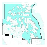
Navionics+ 010-C146230 Canada North Chart - 010-C1462-30 - 155-010C146230F1
Navionics+ Canada, Canada North-Lakes, Rivers and Coastal Marine Chart. Includes a one-year subscription to Daily Updates and advanced features. After a year, renew at a discounted priceVisit Navionics website for full feature list, coverage details and compatibility of Navionics+ content and features with your GPS chartplotter.**NOT COMPATIBLE with GARMIN GPS chartplotters*
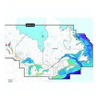
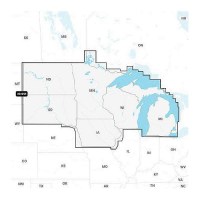
Navionics+ 010-C146630 Canada, East & Great Lakes Chart - 010-C1466-30 - 155-010C146630F1
Navionics+ Canada, East & Great Lakes -Lakes, Rivers and Coastal Marine Chart. Includes a one-year subscription to Daily Updates and advanced features. After a year, renew at a discounted priceVisit Navionics website for full feature list, coverage details and compatibility of Navionics+ content and features with your GPS chartplotter.**NOT COMPATIBLE with GARMIN GPS chartplotters*
Navionics+ 010-C146640 Platinum+Canada, East & Great Lakes Chart - 010-C1466-40 - 155-010C146640F1
Navionics Platinum+ Canada, East & Great Lakes -Lakes, Rivers and Coastal Marine Chart. Platinum+ additinal features include: High resolution relief shading and satellite imagery, sonar imagery, aerial photography and 3D view.Includes a one-year subscription to Daily Updates and advanced features. After a year, renew at a discounted price.Visit Navionics website for full feature list, coverage details and compatibility of Navionics+ content and features with your GPS chartplotter.**NOT COMPATIBLE with GARMIN GPS chartplotters*
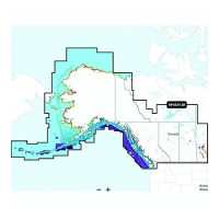
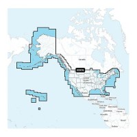
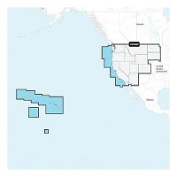
Navionics+ 010-C146730 Canada, West & Alaska Chart - 010-C1467-30 - 155-010C146730F1
Navionics+ Canada, West & Alaska -Lakes, Rivers and Coastal Marine Chart. Includes a one-year subscription to Daily Updates and advanced features. After a year, renew at a discounted priceVisit Navionics website for full feature list, coverage details and compatibility of Navionics+ content and features with your GPS chartplotter.**NOT COMPATIBLE with GARMIN GPS chartplotters*
Navionics+ 010-C146740 Platinum+ Canada, West & Alaska Chart - 010-C1467-40 - 155-010C146740F1
Navionics Platinum+ Canada, West & Alaska -Lakes, Rivers and Coastal Marine Chart. Platinum+ additional features include: High resolution relief shading and satellite imagery, sonar imagery, aerial photography and 3D view.Includes a one-year subscription to Daily Updates and advanced features. After a year, renew at a discounted price.Visit Navionics website for full feature list, coverage details and compatibility of Navionics+ content and features with your GPS chartplotter.**NOT COMPATIBLE with GARMIN GPS chartplotters*
Navy Blu - Surshade Std Canvas W Front Pocket And Boot - 2021014017 - 239-2021014017F1
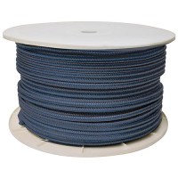
Navy Double Braid, 3/8" X 600' - 47060 - 50-47060F1
Excellent high grade nylon. Long wearing and resists kinking. Can be used to make dock, anchor and mooring lines.

Needle Bearing Assembly Grease - 8M0071836 - 710-92-8M0071836F1
For assembly of internal engine parts. Sold in case packs only.
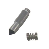
Needle/Seat Kit - 7824 - 710-1395-7824F1
For Mercury and Mariner outboards.
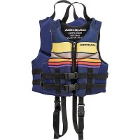
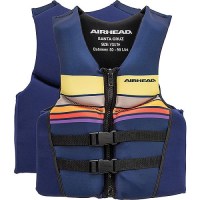
Neo Pet Vest Large Yellow - 15720040004019 - 116-15720040004019F1
Neolite -Santa Cruz 2Xl Nv - 30070-12-B-Nb - 253-3007012Bnbf1
Neolite -Santa Cruz M Nv - 30070-09-B-Nb - 253-3007009Bnbf1
Neolite -Santa Cruz S Nv - 30070-08-B-Nb - 253-3007008Bnbf1
Neolite -Santa Cruz Xl Nv - 30070-11-B-Nb - 253-3007011Bnbf1
Neolite-Santa Cruz Child-Nv - 30070-02-B-Nb - 253-3007002Bnbf1
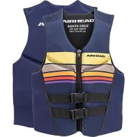
Neolite-Santa Cruz Xs, Nv - 30070-07-B-Nb - 253-3007007Bnbf1
Neolite-Santa Cruz Youth-Nv - 30070-03-B-Nb - 253-3007003Bnbf1
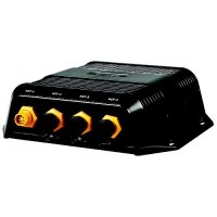
Nep-2 Network Expansion Port - 000-10029-001 - 149-00010029001F1
Expands ethernet network connectivity for multiple displays and modules.
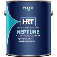
Neptune 5 Hybrid Antifouling Paint - 1124306 - 93-1243Gf1
Hybrid AntifoulingNeptune 5 uses the latest technology available to create a hybrid paint film strong enough to handle the tough marine environment without building up over time. Its crossbreed finish is extremely durable like a hard paint, yet it self-polishes over time like a seasonal ablative. Durable, smooth, thin-film finish resists build upProvides cost-effective seasonal antifouling protectionEasy to apply, safer to use, low VOCCompatible over all bottom paintsSimple soap and water clean up
Neptune 5 Hybrid Antifouling Paint - 1134306 - 93-1343Gf1
Hybrid AntifoulingNeptune 5 uses the latest technology available to create a hybrid paint film strong enough to handle the tough marine environment without building up over time. Its crossbreed finish is extremely durable like a hard paint, yet it self-polishes over time like a seasonal ablative. Durable, smooth, thin-film finish resists build upProvides cost-effective seasonal antifouling protectionEasy to apply, safer to use, low VOCCompatible over all bottom paintsSimple soap and water clean up
Neptune 5 Hybrid Antifouling Paint - 1164306 - 93-1643Gf1
Hybrid AntifoulingNeptune 5 uses the latest technology available to create a hybrid paint film strong enough to handle the tough marine environment without building up over time. Its crossbreed finish is extremely durable like a hard paint, yet it self-polishes over time like a seasonal ablative. Durable, smooth, thin-film finish resists build upProvides cost-effective seasonal antifouling protectionEasy to apply, safer to use, low VOCCompatible over all bottom paintsSimple soap and water clean up
Neptune 5 Hybrid Antifouling Paint - 1184306 - 93-1843Gf1
Hybrid AntifoulingNeptune 5 uses the latest technology available to create a hybrid paint film strong enough to handle the tough marine environment without building up over time. Its crossbreed finish is extremely durable like a hard paint, yet it self-polishes over time like a seasonal ablative. Durable, smooth, thin-film finish resists build upProvides cost-effective seasonal antifouling protectionEasy to apply, safer to use, low VOCCompatible over all bottom paintsSimple soap and water clean up
Neptune 5 Hybrid Antifouling Paint - 93-1843Q - 93-1843Qf1
Hybrid AntifoulingNeptune 5 uses the latest technology available to create a hybrid paint film strong enough to handle the tough marine environment without building up over time. Its crossbreed finish is extremely durable like a hard paint, yet it self-polishes over time like a seasonal ablative. Durable, smooth, thin-film finish resists build upProvides cost-effective seasonal antifouling protectionEasy to apply, safer to use, low VOCCompatible over all bottom paintsSimple soap and water clean up
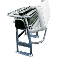
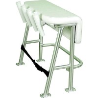
Neptune Ii Leaning Post - L10-1003-1 - 236-L1010031F1
Polished anodized aluminum pipe construction Soft removable under-seat storage tote4 welded-in rod holdersAdjustable footrestUpholstered cushion seat and under-seat storageWeather-resistant, upholstered, padded vinyl seat always looks new3-year warranty.Breaks down to UPS'able packageFootprint: 15" x 35"
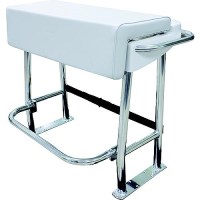
Neptune Iii Standard Leaning Post - L10-2005Bsa-1 - 236-L102005Bsa1F1
Designed with the fishing enthusiast in mind, the four rod holders on the Neptune III Leaning Post are the perfect helm support for carrying multiple rods in center console boats 25' and under. Its practical, smooth upholstery design features an anodized aluminum frame, a folding footrest and a large under-seat storage space for coolers or tackle boxes. Rod holders sit at a 15° angle. Mildew, fungus and UV-resistant marine-grade vinyl fabric. Storage space for a 72-quart cooler, which secures in place using a strap (included). 3-year limited warranty.
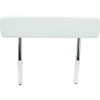
Neptune Premium Leaning Post - L10-1001-1 - 236-L1010011F1
Breaks down to UPS'able packageDim. (w/o backrest): 27" L x 39" W x 31-1/2" H Dim. (w/backrest): 27" L x 39" W x 49" H
Network Poe Isolation Coupler - 010-10580-10 - 322-0101058010F1

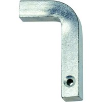
Neut. Safety Switch Kit Ch4400 - Ca68075P - 1-Ca68075Pf1
For use with CH4400 series controls.

Neutral Safety Switch - 300928 - 1-300928F1
For use with CH4400 series controls.
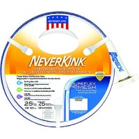
Neverkink Water Hose 1/2" X 25' - 7602-25 - 188-760225F1
Guaranteed no kink, no twist, no tangle Reflex Mesh™ causes loops to self straighten. Drinking water safe.
Neverkink Water Hose 5/8" X 25' - 860225 - 188-860225F1
Guaranteed no kink, no twist, no tangle Reflex Mesh™ causes loops to self straighten. Drinking water safe.
Neverkink Water Hose 5/8" X 50' - 860250 - 188-860250F1
Guaranteed no kink, no twist, no tangle Reflex Mesh™ causes loops to self straighten. Drinking water safe.
Neverkink Water Hose 5/8" X 75' - 860275 - 188-860275F1
Guaranteed no kink, no twist, no tangle Reflex Mesh™ causes loops to self straighten. Drinking water safe.


New England Ropes7182509 Dock Line 4-Pack W/Bucket - 7182509 - 325-7182509F1
The dock lines are provided with a spliced eye and bitter end heat sealed and whipped. Includes 2ea 15' and 2ea 25' dock lines in a handy storage bucket. Ready made with professional 12" eye splice and bitter end heat sealed and whippedDelivered in a practical storage bucket, it is easy to stow aboard your vessel8,500 lb. breaking strength in 15' & 25' lengthsMaking it the ideal docking solution in any harbor, marina boat well, launch ramp
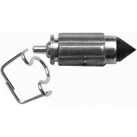
New Snap L-Pin (Bulk) Ea Bell Rv Rvx - 90-03-9230 - 286-90039230F1
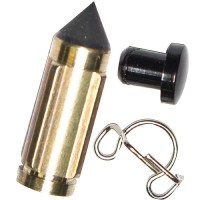
New Snap L-Pins Pair Clam Pkg - 95-01-9430 - 286-95019430F1
A convenient way to buy replacement parts for your Equal-i-zer® hitch. Don't stress over a lost pin or clip. Keep these handy clamshell packages with extra pins and clips on hand just in case.
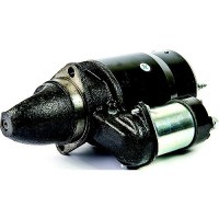
New Starter - 18-5907 - 47-5907F1
Remanufactured. Top mount rear entry starter for opposite rotation GM & Ford engine. Will also replace standard rotation (will not replace non-starter mounted solenoids). Mercruiser built 4 cylinder 165/170/180/190/470/485/488Replaces Mercury: 50-72550A2, 50-79604A3, & 50-97499A2, R4.OMC: 981289, 982202. Crusader: 42091
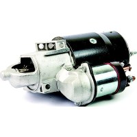
New Starter - 18-5908 - 47-5908F1
New Starter CW rotation,Top mount rear entry starter.
New Starter - 18-5910 - 47-5910F1
Small block V6 & V8 W/ 14-1/4" flywheel & bottom mountOffset bolt pattern, standard rotationReplaces: Mercruiser 50-12177A2, 50-99418A2
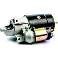
New Starter - 18-5911 - 47-5911F1
Bottom mount straight across bolt patternReplaces: Mercury 50-76965A4, 50-99417A2, 50-99419A3, 50-17251A3, 50-77328A3
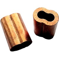
Newco Nico316 Copper Swage Sleeves, 3/16" - Nico316 - 935-Nico316F1
Plain copper oval sleeves for eye splices.
Newco Nico516 Copper Swage Sleeves, 5/16" - Nico516 - 935-Nico516F1
Plain copper oval sleeves for eye splices.

Newport Explorer Lpg Heater - 00-New-Explorer - 163-00Newexplorerf1
Nextel Kit Suede Primer Wht Qt Pmg - 14300.9125.3 Quart - 96-9125Qf1
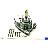
Nfb 4.2 Tilt Helm - Sh91526P - 1-Sh91526Pf1
Single cable No Feedback tilt helm. For engnies up to V6 where single cable steering is used. Requires separate tilt mechanism SH91800P.
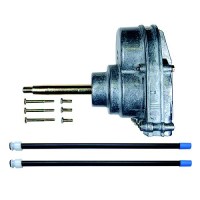
Nfb™ 4.2 Steering Helm, Dual - Sh4920P - 1-Sh4920Pf1
Two bolts secure QC cable to helmOne bolt holds spent travel tube.No feedback feature
Nfb™ 4.2 Steering Helm, Single - Sh4910P - 1-Sh4910Pf1
Two bolts secure QC cable to helmOne bolt holds spent travel tube.No feedback feature
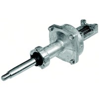
Nfb™ Rack & Nfb™ Pro Rack™ - Backmount - Sh5230P - 1-Sh5230Pf1
Four bolts and nuts secure cable's rack housing to helmDual cable has one rack housing with two cables attached. Single helm works on both single and dual cable applications. Helm requires current generation rack cables (will not bolt up to older style cables)Helm has No FeedBack™ featureHelm/cable install as unit from back of dashFits: SS151XX (NFB Rack Single Cable), SS152XX (NFB Pro Rack Dual Cable)
Nfb™ Saft-T Ii Rotary™ Helm - Sh5150P - 1-Sh5150Pf1
Collet & hitch pin secure QC cable to helmOne bolt holds spent travel tube
Ngk Ilkar7K @4 Ss<33-8M0178257 - 8M0180173 - 710-33-8M0180173F1
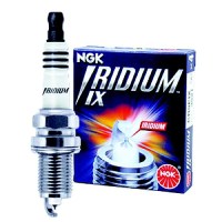
Ngk Iridium Ix Spark Plugs, Bpr7Eix #4055 4/Pack - 4055 - 41-Bpr7Eixf1
Designed specifically for the performance enthusiast. Iridium IX offers extreme ignitability, improved throttle response and superior anti-fouling.Fine-tipped iridium-center electrode ensures high durability and consistently stable sparkIridium alloy with an extremely high melting pointTapered ground electrode maximizes fuel burnOutstanding acceleration, high fuel efficiency and durabilityUltimate design, technology and performanceSold in standard pack only
Ngk Iridium Ix Spark Plugs, Bpr8Eix #6684 4/Pack - 6684 - 41-Bpr8Eixf1
Designed specifically for the performance enthusiast. Iridium IX offers extreme ignitability, improved throttle response and superior anti-fouling.Fine-tipped iridium-center electrode ensures high durability and consistently stable sparkIridium alloy with an extremely high melting pointTapered ground electrode maximizes fuel burnOutstanding acceleration, high fuel efficiency and durabilityUltimate design, technology and performanceSold in standard pack only
Ngk Iridium Ix Spark Plugs, Bpr9Eix #6853 4/Pack - 6853 - 41-Bpr9Eixf1
Designed specifically for the performance enthusiast. Iridium IX offers extreme ignitability, improved throttle response and superior anti-fouling.Fine-tipped iridium-center electrode ensures high durability and consistently stable sparkIridium alloy with an extremely high melting pointTapered ground electrode maximizes fuel burnOutstanding acceleration, high fuel efficiency and durabilityUltimate design, technology and performanceSold in standard pack only
Ngk Iridium Ix Spark Plugs, Br6Fix #2318 4/Pack - 2318 - 41-Br6Fixf1
Designed specifically for the performance enthusiast. Iridium IX offers extreme ignitability, improved throttle response and superior anti-fouling.Fine-tipped iridium-center electrode ensures high durability and consistently stable sparkIridium alloy with an extremely high melting pointTapered ground electrode maximizes fuel burnOutstanding acceleration, high fuel efficiency and durabilityUltimate design, technology and performanceSold in standard pack only