

Lowrance
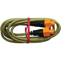
Ethext-6Yl Ethernet Extension Cable, 6' - 000-0127-51 - 149-000012751F1
Allows for video to be shared between commpatible displays.
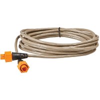
Ethext-25Yl Ethernet Extension Cable, 25' - 000-0127-30 - 149-000012730F1
Allows for video to be shared between commpatible displays.
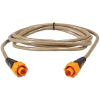
Ethext-15Yl Ethernet Extension Cable, 15' - 000-0127-29 - 149-000012729F1
Allows for video to be shared between commpatible displays.
C-Map Mnay216Ms Reveal Chart, Canada Lakes - M-Na-Y216-Ms - 149-Mnay216Msf1
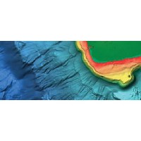
REVEAL charts bring you the very best of C-MAP, including game-changing Shaded Relief © bringing the world around and beneath you to life in a completely new way. Full-Featured Vector ChartsDetailed Marina Port PlansShaded ReliefDynamic Raster ChartsHi-Res BathymetryAerial PhotographyIntegrated Genesis LayerSatellite OverlayCustom Depth ShadingSubscription-Free Easy Routing™12 Months' Free UpdatesTides & Currents For compatibility info visit c-map.com
C-Map Mnay215Ms Reveal Chart, Us Lakes Lakes South Central - M-Na-Y215-Ms - 149-Mnay215Msf1
REVEAL charts bring you the very best of C-MAP, including game-changing Shaded Relief © bringing the world around and beneath you to life in a completely new way. Full-Featured Vector ChartsDetailed Marina Port PlansShaded ReliefDynamic Raster ChartsHi-Res BathymetryAerial PhotographyIntegrated Genesis LayerSatellite OverlayCustom Depth ShadingSubscription-Free Easy Routing™12 Months' Free UpdatesTides & Currents For compatibility info visit c-map.com
C-Map Mnay214Ms Reveal Chart, Us Lakes South East - M-Na-Y214-Ms - 149-Mnay214Msf1
REVEAL charts bring you the very best of C-MAP, including game-changing Shaded Relief © bringing the world around and beneath you to life in a completely new way. Full-Featured Vector ChartsDetailed Marina Port PlansShaded ReliefDynamic Raster ChartsHi-Res BathymetryAerial PhotographyIntegrated Genesis LayerSatellite OverlayCustom Depth ShadingSubscription-Free Easy Routing™12 Months' Free UpdatesTides & Currents For compatibility info visit c-map.com
C-Map Mnay213Ms Reveal Chart, Us Lakes North East - M-Na-Y213-Ms - 149-Mnay213Msf1
REVEAL charts bring you the very best of C-MAP, including game-changing Shaded Relief © bringing the world around and beneath you to life in a completely new way. Full-Featured Vector ChartsDetailed Marina Port PlansShaded ReliefDynamic Raster ChartsHi-Res BathymetryAerial PhotographyIntegrated Genesis LayerSatellite OverlayCustom Depth ShadingSubscription-Free Easy Routing™12 Months' Free UpdatesTides & Currents For compatibility info visit c-map.com
C-Map Mnay212Ms Reveal Chart, Us Lakes North Central - M-Na-Y212-Ms - 149-Mnay212Msf1
REVEAL charts bring you the very best of C-MAP, including game-changing Shaded Relief © bringing the world around and beneath you to life in a completely new way. Full-Featured Vector ChartsDetailed Marina Port PlansShaded ReliefDynamic Raster ChartsHi-Res BathymetryAerial PhotographyIntegrated Genesis LayerSatellite OverlayCustom Depth ShadingSubscription-Free Easy Routing™12 Months' Free UpdatesTides & Currents For compatibility info visit c-map.com
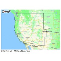
C-Map Mnay211Ms Reveal Chart, Us Lakes Lakes West - M-Na-Y211-Ms - 149-Mnay211Msf1
REVEAL charts bring you the very best of C-MAP, including game-changing Shaded Relief © bringing the world around and beneath you to life in a completely new way. Full-Featured Vector ChartsDetailed Marina Port PlansShaded ReliefDynamic Raster ChartsHi-Res BathymetryAerial PhotographyIntegrated Genesis LayerSatellite OverlayCustom Depth ShadingSubscription-Free Easy Routing™12 Months' Free UpdatesTides & Currents For compatibility info visit c-map.com
C-Map Mnay210Ms Reveal Chart, Hawaii, Marshall Is., French Polynesia - M-Na-Y210-Ms - 149-Mnay210Msf1
REVEAL charts bring you the very best of C-MAP, including game-changing Shaded Relief © bringing the world around and beneath you to life in a completely new way. Full-Featured Vector ChartsDetailed Marina Port PlansShaded ReliefDynamic Raster ChartsHi-Res BathymetryAerial PhotographyIntegrated Genesis LayerSatellite OverlayCustom Depth ShadingSubscription-Free Easy Routing™12 Months' Free UpdatesTides & Currents For compatibility info visit c-map.com
C-Map Mnay209Ms Reveal Chart, Canada North & East - M-Na-Y209-Ms - 149-Mnay209Msf1
REVEAL charts bring you the very best of C-MAP, including game-changing Shaded Relief © bringing the world around and beneath you to life in a completely new way. Full-Featured Vector ChartsDetailed Marina Port PlansShaded ReliefDynamic Raster ChartsHi-Res BathymetryAerial PhotographyIntegrated Genesis LayerSatellite OverlayCustom Depth ShadingSubscription-Free Easy Routing™12 Months' Free UpdatesTides & Currents For compatibility info visit c-map.com
C-Map Mnay208Ms Reveal Chart, Alaska - M-Na-Y208-Ms - 149-Mnay208Msf1
REVEAL charts bring you the very best of C-MAP, including game-changing Shaded Relief © bringing the world around and beneath you to life in a completely new way. Full-Featured Vector ChartsDetailed Marina Port PlansShaded ReliefDynamic Raster ChartsHi-Res BathymetryAerial PhotographyIntegrated Genesis LayerSatellite OverlayCustom Depth ShadingSubscription-Free Easy Routing™12 Months' Free UpdatesTides & Currents For compatibility info visit c-map.com
C-Map Mnay207Ms Reveal Chart, British Columbia & Puget Sound - M-Na-Y207-Ms - 149-Mnay207Msf1
REVEAL charts bring you the very best of C-MAP, including game-changing Shaded Relief © bringing the world around and beneath you to life in a completely new way. Full-Featured Vector ChartsDetailed Marina Port PlansShaded ReliefDynamic Raster ChartsHi-Res BathymetryAerial PhotographyIntegrated Genesis LayerSatellite OverlayCustom Depth ShadingSubscription-Free Easy Routing™12 Months' Free UpdatesTides & Currents For compatibility info visit c-map.com
C-Map Mnay206Ms Reveal Chart, Us West Coast & Baja California - M-Na-Y206-Ms - 149-Mnay206Msf1
REVEAL charts bring you the very best of C-MAP, including game-changing Shaded Relief © bringing the world around and beneath you to life in a completely new way. Full-Featured Vector ChartsDetailed Marina Port PlansShaded ReliefDynamic Raster ChartsHi-Res BathymetryAerial PhotographyIntegrated Genesis LayerSatellite OverlayCustom Depth ShadingSubscription-Free Easy Routing™12 Months' Free UpdatesTides & Currents For compatibility info visit c-map.com
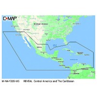
C-Map Mnay205Ms Reveal Chart, Central America & The Caribbean - M-Na-Y205-Ms - 149-Mnay205Msf1
REVEAL charts bring you the very best of C-MAP, including game-changing Shaded Relief © bringing the world around and beneath you to life in a completely new way. Full-Featured Vector ChartsDetailed Marina Port PlansShaded ReliefDynamic Raster ChartsHi-Res BathymetryAerial PhotographyIntegrated Genesis LayerSatellite OverlayCustom Depth ShadingSubscription-Free Easy Routing™12 Months' Free UpdatesTides & Currents For compatibility info visit c-map.com
C-Map Mnay204Ms Reveal Chart, Gulf Of Mexico & The Bahamas - M-Na-Y204-Ms - 149-Mnay204Msf1
REVEAL charts bring you the very best of C-MAP, including game-changing Shaded Relief © bringing the world around and beneath you to life in a completely new way. Full-Featured Vector ChartsDetailed Marina Port PlansShaded ReliefDynamic Raster ChartsHi-Res BathymetryAerial PhotographyIntegrated Genesis LayerSatellite OverlayCustom Depth ShadingSubscription-Free Easy Routing™12 Months' Free UpdatesTides & Currents For compatibility info visit c-map.com
C-Map Mnay203Ms Reveal Chart, Chesapeake Bay To The Bahamas - M-Na-Y203-Ms - 149-Mnay203Msf1
REVEAL charts bring you the very best of C-MAP, including game-changing Shaded Relief © bringing the world around and beneath you to life in a completely new way. Full-Featured Vector ChartsDetailed Marina Port PlansShaded ReliefDynamic Raster ChartsHi-Res BathymetryAerial PhotographyIntegrated Genesis LayerSatellite OverlayCustom Depth ShadingSubscription-Free Easy Routing™12 Months' Free UpdatesTides & Currents For compatibility info visit c-map.com
C-Map Mnay202Ms Reveal Chart, Nova Scotia To Chesapeake Bay - M-Na-Y202-Ms - 149-Mnay202Msf1
REVEAL charts bring you the very best of C-MAP, including game-changing Shaded Relief © bringing the world around and beneath you to life in a completely new way. Full-Featured Vector ChartsDetailed Marina Port PlansShaded ReliefDynamic Raster ChartsHi-Res BathymetryAerial PhotographyIntegrated Genesis LayerSatellite OverlayCustom Depth ShadingSubscription-Free Easy Routing™12 Months' Free UpdatesTides & Currents For compatibility info visit c-map.com
C-Map Mnay201Ms Reveal Chart, Great Lakes To Nova Scotia - M-Na-Y201-Ms - 149-Mnay201Msf1
REVEAL charts bring you the very best of C-MAP, including game-changing Shaded Relief © bringing the world around and beneath you to life in a completely new way. Full-Featured Vector ChartsDetailed Marina Port PlansShaded ReliefDynamic Raster ChartsHi-Res BathymetryAerial PhotographyIntegrated Genesis LayerSatellite OverlayCustom Depth ShadingSubscription-Free Easy Routing™12 Months' Free UpdatesTides & Currents For compatibility info visit c-map.com
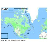
C-Map Mnay200Ms Discover Chart, North America - M-Na-Y200-Ms - 149-Mnay200Msf1
DISCOVER all you need to make the most of your time on the water. Full-featured Vector Charts with High-Res Bathy, including integrated Genesis® social data, subscription-free Easy Routing™ and Custom Depth Shading. Full Featured Vector ChartsTides & CurrentsHi Res Bathymetry LayerDetailed Marina Port PlansIntegrated Genesis LayerCustom Depth Shading12 Months' Free UpdatesSubscription-Free Easy Routing For compatibility inf visit c-map.com
C-Map 025Sd Max Sd Micro Sd Chart, Canada West Including Puget Sound - M-Na-M025-Ms - 149-025Sdf1
C-MAP MAX-N cartography gives Lowrance, Simrad and B&G customers access to C-MAP by Jeppesen's extensive worldwide portfolio and all the necessary chart data to enjoy any boating adventure, anywhere in the world and a FREE 1-year subscription of insight genesis with MAX-N - a $99 value (USD).