
Miscellaneous
Nitrile 7Milblk Glove Xl100/Bx 7 Mil Powder-Free Exam-Grade Raven 100Bx Black - 66519 - 991-66519F1
Nitrile 7Mil Blk Glovem 100/Bx 7 Mil Powder-Free Exam-Grade Raven 100Bx Black - 66517 - 991-66517F1
Nitrile 7Mil Blk Glovel 100/Bx 7 Mil Powder-Free Exam-Grade Raven 100Bx Black - 66518 - 991-66518F1
Nitrile 5Mil Blkglovexl 100/Bx 5 Mil Powder-Free Exam-Grade Dermapro 100Bx Black - 66544 - 991-66544F1
Nitrile 5Mil Blkglove M 100/Bx 5 Mil Powder-Free Exam-Grade Dermapro 100Bx Black - 66542 - 991-66542F1
Nitrile 5Mil Blkglove L 100/Bx 5 Mil Powder-Free Exam-Grade Dermapro 100Bx Black - 66543 - 991-66543F1
Ngk Ilkar7K @4 Ss<33-8M0178257 - 8M0180173 - 710-33-8M0180173F1
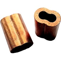
Newco Nico516 Copper Swage Sleeves, 5/16" - Nico516 - 935-Nico516F1
Plain copper oval sleeves for eye splices.
Newco Nico316 Copper Swage Sleeves, 3/16" - Nico316 - 935-Nico316F1
Plain copper oval sleeves for eye splices.


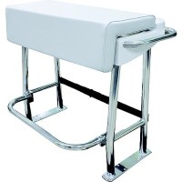
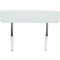
Neptune Premium Leaning Post - L10-1001-1 - 236-L1010011F1
Breaks down to UPS'able packageDim. (w/o backrest): 27" L x 39" W x 31-1/2" H Dim. (w/backrest): 27" L x 39" W x 49" H
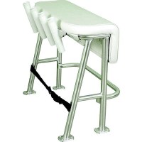
Neptune Iii Standard Leaning Post - L10-2005Bsa-1 - 236-L102005Bsa1F1
Designed with the fishing enthusiast in mind, the four rod holders on the Neptune III Leaning Post are the perfect helm support for carrying multiple rods in center console boats 25' and under. Its practical, smooth upholstery design features an anodized aluminum frame, a folding footrest and a large under-seat storage space for coolers or tackle boxes. Rod holders sit at a 15° angle. Mildew, fungus and UV-resistant marine-grade vinyl fabric. Storage space for a 72-quart cooler, which secures in place using a strap (included). 3-year limited warranty.
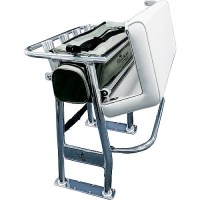
Neptune Ii Leaning Post - L10-1003-1 - 236-L1010031F1
Polished anodized aluminum pipe construction Soft removable under-seat storage tote4 welded-in rod holdersAdjustable footrestUpholstered cushion seat and under-seat storageWeather-resistant, upholstered, padded vinyl seat always looks new3-year warranty.Breaks down to UPS'able packageFootprint: 15" x 35"
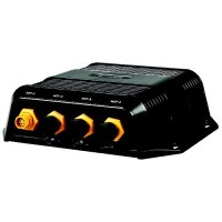
Nep-2 Network Expansion Port - 000-10029-001 - 149-00010029001F1
Expands ethernet network connectivity for multiple displays and modules.
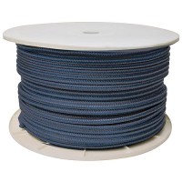
Navy Double Braid, 3/8" X 600' - 47060 - 50-47060F1
Excellent high grade nylon. Long wearing and resists kinking. Can be used to make dock, anchor and mooring lines.
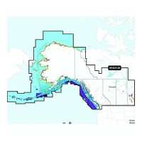
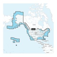
Navionics+ 010-C146740 Platinum+ Canada, West & Alaska Chart - 010-C1467-40 - 155-010C146740F1
Navionics Platinum+ Canada, West & Alaska -Lakes, Rivers and Coastal Marine Chart. Platinum+ additional features include: High resolution relief shading and satellite imagery, sonar imagery, aerial photography and 3D view.Includes a one-year subscription to Daily Updates and advanced features. After a year, renew at a discounted price.Visit Navionics website for full feature list, coverage details and compatibility of Navionics+ content and features with your GPS chartplotter.**NOT COMPATIBLE with GARMIN GPS chartplotters*
Navionics+ 010-C146730 Canada, West & Alaska Chart - 010-C1467-30 - 155-010C146730F1
Navionics+ Canada, West & Alaska -Lakes, Rivers and Coastal Marine Chart. Includes a one-year subscription to Daily Updates and advanced features. After a year, renew at a discounted priceVisit Navionics website for full feature list, coverage details and compatibility of Navionics+ content and features with your GPS chartplotter.**NOT COMPATIBLE with GARMIN GPS chartplotters*
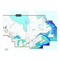
Navionics+ 010-C146640 Platinum+Canada, East & Great Lakes Chart - 010-C1466-40 - 155-010C146640F1
Navionics Platinum+ Canada, East & Great Lakes -Lakes, Rivers and Coastal Marine Chart. Platinum+ additinal features include: High resolution relief shading and satellite imagery, sonar imagery, aerial photography and 3D view.Includes a one-year subscription to Daily Updates and advanced features. After a year, renew at a discounted price.Visit Navionics website for full feature list, coverage details and compatibility of Navionics+ content and features with your GPS chartplotter.**NOT COMPATIBLE with GARMIN GPS chartplotters*
Navionics+ 010-C146630 Canada, East & Great Lakes Chart - 010-C1466-30 - 155-010C146630F1
Navionics+ Canada, East & Great Lakes -Lakes, Rivers and Coastal Marine Chart. Includes a one-year subscription to Daily Updates and advanced features. After a year, renew at a discounted priceVisit Navionics website for full feature list, coverage details and compatibility of Navionics+ content and features with your GPS chartplotter.**NOT COMPATIBLE with GARMIN GPS chartplotters*
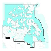
Navionics+ 010-C146230 Canada North Chart - 010-C1462-30 - 155-010C146230F1
Navionics+ Canada, Canada North-Lakes, Rivers and Coastal Marine Chart. Includes a one-year subscription to Daily Updates and advanced features. After a year, renew at a discounted priceVisit Navionics website for full feature list, coverage details and compatibility of Navionics+ content and features with your GPS chartplotter.**NOT COMPATIBLE with GARMIN GPS chartplotters*
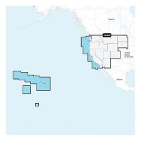
Navionics 010C137140 Platinum+ Cartography, U.S. West - 010-C1371-40 - 155-010C137140F1
THE NAVIONICS SUBSCRIPTION: A one-year subscription to Daily Updates and advanced features is included when you purchase any new Navionics Platinum+ mapping solution. After a year, you can renew at a discounted price CHARTS AND UPDATES:Nautical Chart - Comprehensive charts are derived from multiple official, government and private sources, displayed in a familiar look and feelSonarChart HD Bathymetry - Innovative 1' (0.5 m) bathymetry charts are created by using Navionics proprietary systems that augment existing content with sonar data contributed by the boating communityCommunity Edits - Get useful local knowledge from edits made by users of the Navionics Boating app on your compatible smart device.Daily Updates - Up to 5,000 daily updates to our charts give you the most accurate, most current Navionics data availableInland Content: 42,000+ lakes (varies by coverage area) ADVANCED FEATURES:Dock-to-dock Route Guidance - Start your trip with a suggested pathSonarChart Live Mapping Feature - Watch new HD depth maps develop in real time as your boat moves through the waterAdvanced Map Options - Customize your view to focus on the details that matter mostPlotter Sync - Transfer routes and markers, update chart layers and more - between your compatible chartplotter and the Boating app OVERLAYS:Relief Shading - Get an easy-to-interpret, clearer view of bottom structure. Check coverageSatellite Imagery with SonarChart Shading Overlay - Experience an enhanced awareness above and below the waterline. Check coverageSonar Imagery - View bottom hardness clearly and in contrasting color PLATINUM+ ADDITIONAL VIEWING OPTIONS:3D View - Adjust the perspective of your chart view to highlight key features and enhance awarenessAerial Photos - Get a better sense of your surroundingsVisit Navionics website for full feature list, coverage details and compatibility of Platinum+ content and features with your GPS chartplotter.**NOT COMPATIBLE with GARMIN GPS chartplotters**
Navionics 010C137130 Navionics+ Cartography, U.S. West - 010-C1371-30 - 155-010C137130F1
THE NAVIONICS SUBSCRIPTION: A one-year subscription to Daily Updates and advanced features is included when you purchase any Navionics+ mapping solution. After a year, you can renew at a discounted price.CHARTS AND UPDATES:Nautical Chart - Comprehensive charts are derived from multiple official, government and private sources, displayed in a familiar look and feel.SonarChart HD Bathymetry - Innovative 1' (0.5 m) bathymetry charts are created by using Navionics proprietary systems that augment existing content with sonar data contributed by the boating community.Community Edits - Get useful local knowledge from edits made by users of the Navionics Boating app on your compatible smart device.Daily Updates - Up to 5,000 daily updates to our charts give you the most accurate, most current data availableInland Content: 42,000+ lakes (varies by coverage area)ADVANCED FEATURES:Dock-to-dock Route Guidance - Start your trip with a suggested dock-to-dock route.Advanced Map Options - Customize your view to focus on the details that matter most.Plotter Sync - Transfer routes and markers, update chart layers and more - between your compatible chartplotter and the Boating app.SonarChart Live Mapping Feature - Watch new HD depth maps develop in real time as your boat moves through the water. Visit Navionics website for full feature list, coverage details and compatibility of Navionics+ content and features with your GPS chartplotter. **NOT COMPATIBLE with GARMIN GPS chartplotters**
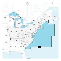
Navionics 010C137040 Platinum+ Cartography, U.S. East - 010-C1370-40 - 155-010C137040F1
THE NAVIONICS SUBSCRIPTION: A one-year subscription to Daily Updates and advanced features is included when you purchase any new Navionics Platinum+ mapping solution. After a year, you can renew at a discounted price CHARTS AND UPDATES:Nautical Chart - Comprehensive charts are derived from multiple official, government and private sources, displayed in a familiar look and feelSonarChart HD Bathymetry - Innovative 1' (0.5 m) bathymetry charts are created by using Navionics proprietary systems that augment existing content with sonar data contributed by the boating communityCommunity Edits - Get useful local knowledge from edits made by users of the Navionics Boating app on your compatible smart device.Daily Updates - Up to 5,000 daily updates to our charts give you the most accurate, most current Navionics data availableInland Content: 42,000+ lakes (varies by coverage area) ADVANCED FEATURES:Dock-to-dock Route Guidance - Start your trip with a suggested pathSonarChart Live Mapping Feature - Watch new HD depth maps develop in real time as your boat moves through the waterAdvanced Map Options - Customize your view to focus on the details that matter mostPlotter Sync - Transfer routes and markers, update chart layers and more - between your compatible chartplotter and the Boating app OVERLAYS:Relief Shading - Get an easy-to-interpret, clearer view of bottom structure. Check coverageSatellite Imagery with SonarChart Shading Overlay - Experience an enhanced awareness above and below the waterline. Check coverageSonar Imagery - View bottom hardness clearly and in contrasting color PLATINUM+ ADDITIONAL VIEWING OPTIONS:3D View - Adjust the perspective of your chart view to highlight key features and enhance awarenessAerial Photos - Get a better sense of your surroundingsVisit Navionics website for full feature list, coverage details and compatibility of Platinum+ content and features with your GPS chartplotter.**NOT COMPATIBLE with GARMIN GPS chartplotters**
Navionics 010C137030 Navionics+ Cartography, U.S. East - 010-C1370-30 - 155-010C137030F1
THE NAVIONICS SUBSCRIPTION: A one-year subscription to Daily Updates and advanced features is included when you purchase any Navionics+ mapping solution. After a year, you can renew at a discounted price.CHARTS AND UPDATES:Nautical Chart - Comprehensive charts are derived from multiple official, government and private sources, displayed in a familiar look and feel.SonarChart HD Bathymetry - Innovative 1' (0.5 m) bathymetry charts are created by using Navionics proprietary systems that augment existing content with sonar data contributed by the boating community.Community Edits - Get useful local knowledge from edits made by users of the Navionics Boating app on your compatible smart device.Daily Updates - Up to 5,000 daily updates to our charts give you the most accurate, most current data availableInland Content: 42,000+ lakes (varies by coverage area)ADVANCED FEATURES:Dock-to-dock Route Guidance - Start your trip with a suggested dock-to-dock route.Advanced Map Options - Customize your view to focus on the details that matter most.Plotter Sync - Transfer routes and markers, update chart layers and more - between your compatible chartplotter and the Boating app.SonarChart Live Mapping Feature - Watch new HD depth maps develop in real time as your boat moves through the water. Visit Navionics website for full feature list, coverage details and compatibility of Navionics+ content and features with your GPS chartplotter. **NOT COMPATIBLE with GARMIN GPS chartplotters**
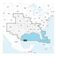
Navionics 010C136940 Platinum+ Cartography, U.S. South - 010-C1369-40 - 155-010C136940F1
THE NAVIONICS SUBSCRIPTION: A one-year subscription to Daily Updates and advanced features is included when you purchase any new Navionics Platinum+ mapping solution. After a year, you can renew at a discounted price CHARTS AND UPDATES:Nautical Chart - Comprehensive charts are derived from multiple official, government and private sources, displayed in a familiar look and feelSonarChart HD Bathymetry - Innovative 1' (0.5 m) bathymetry charts are created by using Navionics proprietary systems that augment existing content with sonar data contributed by the boating communityCommunity Edits - Get useful local knowledge from edits made by users of the Navionics Boating app on your compatible smart device.Daily Updates - Up to 5,000 daily updates to our charts give you the most accurate, most current Navionics data availableInland Content: 42,000+ lakes (varies by coverage area) ADVANCED FEATURES:Dock-to-dock Route Guidance - Start your trip with a suggested pathSonarChart Live Mapping Feature - Watch new HD depth maps develop in real time as your boat moves through the waterAdvanced Map Options - Customize your view to focus on the details that matter mostPlotter Sync - Transfer routes and markers, update chart layers and more - between your compatible chartplotter and the Boating app OVERLAYS:Relief Shading - Get an easy-to-interpret, clearer view of bottom structure. Check coverageSatellite Imagery with SonarChart Shading Overlay - Experience an enhanced awareness above and below the waterline. Check coverageSonar Imagery - View bottom hardness clearly and in contrasting color PLATINUM+ ADDITIONAL VIEWING OPTIONS:3D View - Adjust the perspective of your chart view to highlight key features and enhance awarenessAerial Photos - Get a better sense of your surroundingsVisit Navionics website for full feature list, coverage details and compatibility of Platinum+ content and features with your GPS chartplotter.**NOT COMPATIBLE with GARMIN GPS chartplotters**
Navionics 010C136930 Navionics+ Cartography, U.S. South - 010-C1369-30 - 155-010C136930F1
THE NAVIONICS SUBSCRIPTION: A one-year subscription to Daily Updates and advanced features is included when you purchase any Navionics+ mapping solution. After a year, you can renew at a discounted price.CHARTS AND UPDATES:Nautical Chart - Comprehensive charts are derived from multiple official, government and private sources, displayed in a familiar look and feel.SonarChart HD Bathymetry - Innovative 1' (0.5 m) bathymetry charts are created by using Navionics proprietary systems that augment existing content with sonar data contributed by the boating community.Community Edits - Get useful local knowledge from edits made by users of the Navionics Boating app on your compatible smart device.Daily Updates - Up to 5,000 daily updates to our charts give you the most accurate, most current data availableInland Content: 42,000+ lakes (varies by coverage area)ADVANCED FEATURES:Dock-to-dock Route Guidance - Start your trip with a suggested dock-to-dock route.Advanced Map Options - Customize your view to focus on the details that matter most.Plotter Sync - Transfer routes and markers, update chart layers and more - between your compatible chartplotter and the Boating app.SonarChart Live Mapping Feature - Watch new HD depth maps develop in real time as your boat moves through the water. Visit Navionics website for full feature list, coverage details and compatibility of Navionics+ content and features with your GPS chartplotter. **NOT COMPATIBLE with GARMIN GPS chartplotters**

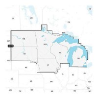
Navionics 010C136840 Platinum+ Cartography, U.S. North - 010-C1368-40 - 155-010C136840F1
THE NAVIONICS SUBSCRIPTION: A one-year subscription to Daily Updates and advanced features is included when you purchase any new Navionics Platinum+ mapping solution. After a year, you can renew at a discounted price CHARTS AND UPDATES:Nautical Chart - Comprehensive charts are derived from multiple official, government and private sources, displayed in a familiar look and feelSonarChart HD Bathymetry - Innovative 1' (0.5 m) bathymetry charts are created by using Navionics proprietary systems that augment existing content with sonar data contributed by the boating communityCommunity Edits - Get useful local knowledge from edits made by users of the Navionics Boating app on your compatible smart device.Daily Updates - Up to 5,000 daily updates to our charts give you the most accurate, most current Navionics data availableInland Content: 42,000+ lakes (varies by coverage area) ADVANCED FEATURES:Dock-to-dock Route Guidance - Start your trip with a suggested pathSonarChart Live Mapping Feature - Watch new HD depth maps develop in real time as your boat moves through the waterAdvanced Map Options - Customize your view to focus on the details that matter mostPlotter Sync - Transfer routes and markers, update chart layers and more - between your compatible chartplotter and the Boating app OVERLAYS:Relief Shading - Get an easy-to-interpret, clearer view of bottom structure. Check coverageSatellite Imagery with SonarChart Shading Overlay - Experience an enhanced awareness above and below the waterline. Check coverageSonar Imagery - View bottom hardness clearly and in contrasting color PLATINUM+ ADDITIONAL VIEWING OPTIONS:3D View - Adjust the perspective of your chart view to highlight key features and enhance awarenessAerial Photos - Get a better sense of your surroundingsVisit Navionics website for full feature list, coverage details and compatibility of Platinum+ content and features with your GPS chartplotter.**NOT COMPATIBLE with GARMIN GPS chartplotters**
Navionics 010C136830 Navionics+ Cartography, U.S. North - 010-C1368-30 - 155-010C136830F1
THE NAVIONICS SUBSCRIPTION: A one-year subscription to Daily Updates and advanced features is included when you purchase any Navionics+ mapping solution. After a year, you can renew at a discounted price.CHARTS AND UPDATES:Nautical Chart - Comprehensive charts are derived from multiple official, government and private sources, displayed in a familiar look and feel.SonarChart HD Bathymetry - Innovative 1' (0.5 m) bathymetry charts are created by using Navionics proprietary systems that augment existing content with sonar data contributed by the boating community.Community Edits - Get useful local knowledge from edits made by users of the Navionics Boating app on your compatible smart device.Daily Updates - Up to 5,000 daily updates to our charts give you the most accurate, most current data availableInland Content: 42,000+ lakes (varies by coverage area)ADVANCED FEATURES:Dock-to-dock Route Guidance - Start your trip with a suggested dock-to-dock route.Advanced Map Options - Customize your view to focus on the details that matter most.Plotter Sync - Transfer routes and markers, update chart layers and more - between your compatible chartplotter and the Boating app.SonarChart Live Mapping Feature - Watch new HD depth maps develop in real time as your boat moves through the water. Visit Navionics website for full feature list, coverage details and compatibility of Navionics+ content and features with your GPS chartplotter. **NOT COMPATIBLE with GARMIN GPS chartplotters**
Navionics 010C136630 Navionics+ Cartography, U.S. & Coastal Canada - 010-C1366-30 - 155-010C136630F1
THE NAVIONICS SUBSCRIPTION: A one-year subscription to Daily Updates and advanced features is included when you purchase any Navionics+ mapping solution. After a year, you can renew at a discounted price.CHARTS AND UPDATES:Nautical Chart - Comprehensive charts are derived from multiple official, government and private sources, displayed in a familiar look and feel.SonarChart HD Bathymetry - Innovative 1' (0.5 m) bathymetry charts are created by using Navionics proprietary systems that augment existing content with sonar data contributed by the boating community.Community Edits - Get useful local knowledge from edits made by users of the Navionics Boating app on your compatible smart device.Daily Updates - Up to 5,000 daily updates to our charts give you the most accurate, most current data availableInland Content: 42,000+ lakes (varies by coverage area)ADVANCED FEATURES:Dock-to-dock Route Guidance - Start your trip with a suggested dock-to-dock route.Advanced Map Options - Customize your view to focus on the details that matter most.Plotter Sync - Transfer routes and markers, update chart layers and more - between your compatible chartplotter and the Boating app.SonarChart Live Mapping Feature - Watch new HD depth maps develop in real time as your boat moves through the water. Visit Navionics website for full feature list, coverage details and compatibility of Navionics+ content and features with your GPS chartplotter. **NOT COMPATIBLE with GARMIN GPS chartplotters**
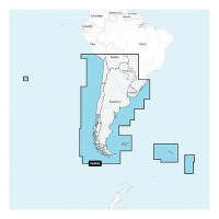
Navionics 010C136540 Platinum+ Cartography, Chile, Argentina & Easter Island - 010-C1365-40 - 155-010C136540F1
THE NAVIONICS SUBSCRIPTION: A one-year subscription to Daily Updates and advanced features is included when you purchase any new Navionics Platinum+ mapping solution. After a year, you can renew at a discounted price CHARTS AND UPDATES:Nautical Chart - Comprehensive charts are derived from multiple official, government and private sources, displayed in a familiar look and feelSonarChart HD Bathymetry - Innovative 1' (0.5 m) bathymetry charts are created by using Navionics proprietary systems that augment existing content with sonar data contributed by the boating communityCommunity Edits - Get useful local knowledge from edits made by users of the Navionics Boating app on your compatible smart device.Daily Updates - Up to 5,000 daily updates to our charts give you the most accurate, most current Navionics data availableInland Content: 42,000+ lakes (varies by coverage area) ADVANCED FEATURES:Dock-to-dock Route Guidance - Start your trip with a suggested pathSonarChart Live Mapping Feature - Watch new HD depth maps develop in real time as your boat moves through the waterAdvanced Map Options - Customize your view to focus on the details that matter mostPlotter Sync - Transfer routes and markers, update chart layers and more - between your compatible chartplotter and the Boating app OVERLAYS:Relief Shading - Get an easy-to-interpret, clearer view of bottom structure. Check coverageSatellite Imagery with SonarChart Shading Overlay - Experience an enhanced awareness above and below the waterline. Check coverageSonar Imagery - View bottom hardness clearly and in contrasting color PLATINUM+ ADDITIONAL VIEWING OPTIONS:3D View - Adjust the perspective of your chart view to highlight key features and enhance awarenessAerial Photos - Get a better sense of your surroundingsVisit Navionics website for full feature list, coverage details and compatibility of Platinum+ content and features with your GPS chartplotter.**NOT COMPATIBLE with GARMIN GPS chartplotters**
Navionics 010C136530 Navionics+ Cartography, Chile, Argentina & Easter Island - 010-C1365-30 - 155-010C136530F1
THE NAVIONICS SUBSCRIPTION: A one-year subscription to Daily Updates and advanced features is included when you purchase any Navionics+ mapping solution. After a year, you can renew at a discounted price.CHARTS AND UPDATES:Nautical Chart - Comprehensive charts are derived from multiple official, government and private sources, displayed in a familiar look and feel.SonarChart HD Bathymetry - Innovative 1' (0.5 m) bathymetry charts are created by using Navionics proprietary systems that augment existing content with sonar data contributed by the boating community.Community Edits - Get useful local knowledge from edits made by users of the Navionics Boating app on your compatible smart device.Daily Updates - Up to 5,000 daily updates to our charts give you the most accurate, most current data availableInland Content: 42,000+ lakes (varies by coverage area)ADVANCED FEATURES:Dock-to-dock Route Guidance - Start your trip with a suggested dock-to-dock route.Advanced Map Options - Customize your view to focus on the details that matter most.Plotter Sync - Transfer routes and markers, update chart layers and more - between your compatible chartplotter and the Boating app.SonarChart Live Mapping Feature - Watch new HD depth maps develop in real time as your boat moves through the water. Visit Navionics website for full feature list, coverage details and compatibility of Navionics+ content and features with your GPS chartplotter. **NOT COMPATIBLE with GARMIN GPS chartplotters**
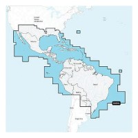
Navionics 010C136440 Platinum+ Cartography, Mexico, Caribbean To Brazil - 010-C1364-40 - 155-010C136440F1
THE NAVIONICS SUBSCRIPTION: A one-year subscription to Daily Updates and advanced features is included when you purchase any new Navionics Platinum+ mapping solution. After a year, you can renew at a discounted price CHARTS AND UPDATES:Nautical Chart - Comprehensive charts are derived from multiple official, government and private sources, displayed in a familiar look and feelSonarChart HD Bathymetry - Innovative 1' (0.5 m) bathymetry charts are created by using Navionics proprietary systems that augment existing content with sonar data contributed by the boating communityCommunity Edits - Get useful local knowledge from edits made by users of the Navionics Boating app on your compatible smart device.Daily Updates - Up to 5,000 daily updates to our charts give you the most accurate, most current Navionics data availableInland Content: 42,000+ lakes (varies by coverage area) ADVANCED FEATURES:Dock-to-dock Route Guidance - Start your trip with a suggested pathSonarChart Live Mapping Feature - Watch new HD depth maps develop in real time as your boat moves through the waterAdvanced Map Options - Customize your view to focus on the details that matter mostPlotter Sync - Transfer routes and markers, update chart layers and more - between your compatible chartplotter and the Boating app OVERLAYS:Relief Shading - Get an easy-to-interpret, clearer view of bottom structure. Check coverageSatellite Imagery with SonarChart Shading Overlay - Experience an enhanced awareness above and below the waterline. Check coverageSonar Imagery - View bottom hardness clearly and in contrasting color PLATINUM+ ADDITIONAL VIEWING OPTIONS:3D View - Adjust the perspective of your chart view to highlight key features and enhance awarenessAerial Photos - Get a better sense of your surroundingsVisit Navionics website for full feature list, coverage details and compatibility of Platinum+ content and features with your GPS chartplotter.**NOT COMPATIBLE with GARMIN GPS chartplotters**
Navionics 010C136430 Navionics+ Cartography, Mexico, Caribbean To Brazil - 010-C1364-30 - 155-010C136430F1
THE NAVIONICS SUBSCRIPTION: A one-year subscription to Daily Updates and advanced features is included when you purchase any Navionics+ mapping solution. After a year, you can renew at a discounted price.CHARTS AND UPDATES:Nautical Chart - Comprehensive charts are derived from multiple official, government and private sources, displayed in a familiar look and feel.SonarChart HD Bathymetry - Innovative 1' (0.5 m) bathymetry charts are created by using Navionics proprietary systems that augment existing content with sonar data contributed by the boating community.Community Edits - Get useful local knowledge from edits made by users of the Navionics Boating app on your compatible smart device.Daily Updates - Up to 5,000 daily updates to our charts give you the most accurate, most current data availableInland Content: 42,000+ lakes (varies by coverage area)ADVANCED FEATURES:Dock-to-dock Route Guidance - Start your trip with a suggested dock-to-dock route.Advanced Map Options - Customize your view to focus on the details that matter most.Plotter Sync - Transfer routes and markers, update chart layers and more - between your compatible chartplotter and the Boating app.SonarChart Live Mapping Feature - Watch new HD depth maps develop in real time as your boat moves through the water. Visit Navionics website for full feature list, coverage details and compatibility of Navionics+ content and features with your GPS chartplotter. **NOT COMPATIBLE with GARMIN GPS chartplotters**
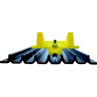
Nauticus Hd800 Hydroplane Performance Trim Tabs - Hd800 - 338-Hd800F1
For Small Boats Under 16' (10 to 40 HP)Increase top speed with hydrodynamic lift. For overall stability, faster time to plane, and elimination of common problems like porpoising and chine walking, HydroPlane provides the port-to-starboard balance that hydrofoils cannot. Installs in Minutes.
Nauticus Ez22Wdb Ez Auxiliary Tie Down, 22" - Ez 22-Wdb - 338-Ez22Wdbf1
Acts as an auxiliary tie down, cleat or boarding handleAuxiliary Tie Down
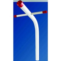
Nat Wht 1076 40-45K - 25006V - 672-25006Vf1
1076 base Tower LED Bulb. Applications include 12 or 24 VDC auto, marine, RV and military vehicles. High Power 5050 SMD LEDs. Beam Pattern 360 degrees.
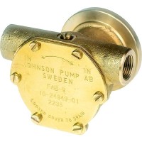
Nanni Diesel F4B-9 Oem#970504001,30105, 538.012.1 - 10-24949-01 - 189-102494901F1
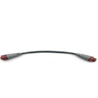
N2K Cable, Med Duty 2M (6.5Ft) Med Duty - 000-14376-001 - 149-00014376001F1
N2K Cable, Med Duty 10M (33Ft) Replaces P/N 941-00014378001 - 000-14378-001 - 149-00014378001F1
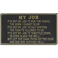
My Job - Fp021 - 22-Fp021F1
The perfect gift item. Made of durable molded plastic. Measure 3" W x 5-1/2" H and have adhesive backing except FP001 measures 2-1/2" W x 3-3/4" H. Easy to apply with no need for screws. Yellow lettering on black background, except where noted.
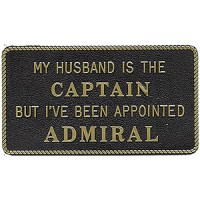
My Husband Is The Captain But - Fp020 - 22-Fp020F1
The perfect gift item. Made of durable molded plastic. Measure 3" W x 5-1/2" H and have adhesive backing except FP001 measures 2-1/2" W x 3-3/4" H. Easy to apply with no need for screws. Yellow lettering on black background, except where noted.
Mx Ps Mono Widerange Amp 500W Mx500/1 - 010-03325-00 - 326-0100332500F1
Mx Ps Mono Widerange Amp 300W Mx300/1 - 010-03324-00 - 326-0100332400F1
Mx Ps Amp 3 Ch Sys (600 W) Mx600/3 - 010-03326-00 - 326-0100332600F1
Mvi Amp Mono Sub Amp (600 W) Mv600/1 - 010-03334-00 - 326-0100333400F1
Mvi Amp Mono Sub Amp (1000 W) Mv1000/1 - 010-03335-00 - 326-0100333500F1
Mvi Amp 5 Channel 1000W Mv1000/5I - 010-03341-00 - 326-0100334100F1
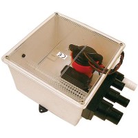
Multi Port Shower Pump - 57151 - 189-57151F1
Compact shower sump offers multiple inlet ports to handle sink, shower and condensation drains all at the same time. Easy to clean inlet screen traps hair and debris before the pump clogs. Tight fitting, see through lid for quick visual inspection. Ultima automatic float switch. Built-in check valve. Fully submersible. Saltwater tough. 3 year warranty. Made in USA.
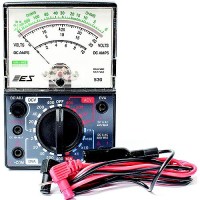
Multi Meter/Dva Tester - 18-9801 - 47-9801F1
For testing Mercury ignition systems.
Multi Measure 8 Oz. - 1000873 - 320-1000873F1
Multiple ratios are printed on the Multi-Measure containers. Bottom is flat for easy mixing. Solvent resistant and safe for use with all paints, pastes, and adhesives.
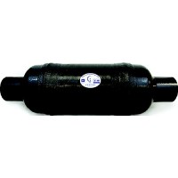
Muffler-Vernatone 6" Round - 1000111 - 383-1000111F1
They are the original and most copied FRP wet muffler in the marine industry. Designed for gasoline or diesel engines, minimizes added back pressure, and will not rust or corrode. Constructed of fire retardant, self extinguishing resins. For use above the waterline.
Muffler-Vernatone 5" Round - 1000108 - 383-1000108F1
They are the original and most copied FRP wet muffler in the marine industry. Designed for gasoline or diesel engines, minimizes added back pressure, and will not rust or corrode. Constructed of fire retardant, self extinguishing resins. For use above the waterline.