


Garmin
Vision Card, Tampa-New Orleans - 010-C0713-00 - 322-010C071300F1
See your precise, on-chart position in relation to navaids, coastal features and restricted areas with premium features found in this detailed marine mapping data. Includes all of the features of our BlueChart® g3 product and more. Shaded depth contours, coastlines, spot soundings, navaids, port plans, wrecks, obstructions, intertidal zones, restricted areas and IALA symbols.Seamless transitions between zoom levels and more continuity across chart boundaries.High resolution satellite imagery for a realistic view of the land and water.Aerial photos of ports, harbors, marinas, waterways, navigational landmarks and other POIs.Auto Guidance technology searches chart data to suggest the best passage to a destination.Mariner Eye View 3-D perspective for a quick, easy position fix.FishEye View 3-D perspective for an underwater view of the sea floor.Safety Shading enables contour shading for all depth contours shallower than your defined safe depths.Fishing Charts to scope out bottom contours and depth soundings with less visual clutter on the display.
Vision Card, New York-Chesapeake - 010-C1004-00 - 322-010C100400F1
See your precise, on-chart position in relation to navaids, coastal features and restricted areas with premium features found in this detailed marine mapping data. Includes all of the features of our BlueChart® g3 product and more. Shaded depth contours, coastlines, spot soundings, navaids, port plans, wrecks, obstructions, intertidal zones, restricted areas and IALA symbols.Seamless transitions between zoom levels and more continuity across chart boundaries.High resolution satellite imagery for a realistic view of the land and water.Aerial photos of ports, harbors, marinas, waterways, navigational landmarks and other POIs.Auto Guidance technology searches chart data to suggest the best passage to a destination.Mariner Eye View 3-D perspective for a quick, easy position fix.FishEye View 3-D perspective for an underwater view of the sea floor.Safety Shading enables contour shading for all depth contours shallower than your defined safe depths.Fishing Charts to scope out bottom contours and depth soundings with less visual clutter on the display.
Vision Card, Morgan City-Brownsville - 010-C0715-00 - 322-010C071500F1
See your precise, on-chart position in relation to navaids, coastal features and restricted areas with premium features found in this detailed marine mapping data. Includes all of the features of our BlueChart® g3 product and more. Shaded depth contours, coastlines, spot soundings, navaids, port plans, wrecks, obstructions, intertidal zones, restricted areas and IALA symbols.Seamless transitions between zoom levels and more continuity across chart boundaries.High resolution satellite imagery for a realistic view of the land and water.Aerial photos of ports, harbors, marinas, waterways, navigational landmarks and other POIs.Auto Guidance technology searches chart data to suggest the best passage to a destination.Mariner Eye View 3-D perspective for a quick, easy position fix.FishEye View 3-D perspective for an underwater view of the sea floor.Safety Shading enables contour shading for all depth contours shallower than your defined safe depths.Fishing Charts to scope out bottom contours and depth soundings with less visual clutter on the display.
Vision Card, Jacksonville-Key West - 010-C0710-00 - 322-010C071000F1
See your precise, on-chart position in relation to navaids, coastal features and restricted areas with premium features found in this detailed marine mapping data. Includes all of the features of our BlueChart® g3 product and more. Shaded depth contours, coastlines, spot soundings, navaids, port plans, wrecks, obstructions, intertidal zones, restricted areas and IALA symbols.Seamless transitions between zoom levels and more continuity across chart boundaries.High resolution satellite imagery for a realistic view of the land and water.Aerial photos of ports, harbors, marinas, waterways, navigational landmarks and other POIs.Auto Guidance technology searches chart data to suggest the best passage to a destination.Mariner Eye View 3-D perspective for a quick, easy position fix.FishEye View 3-D perspective for an underwater view of the sea floor.Safety Shading enables contour shading for all depth contours shallower than your defined safe depths.Fishing Charts to scope out bottom contours and depth soundings with less visual clutter on the display.

Spectra Lc302 Electronic Dsply Garmin - 010-02830-00 - 322-0100283000F1
Control LED lights on your boat from your compatible chartplotter or smartphone with the Garmin Spectra light control module (lights not included). Assign and control different light groups for cup holders, speakers, strip or courtesy lights, and more to create your own vibe. From bow to stern and everything in between, this module lets you control and set up different light groups and scenesControl lights over the NMEA 2000® network with your compatible chartplotter or with the ActiveCaptain® app on your compatible smartphoneSee the beat by syncing the LED lights to the music track with the audio sync featureControl LED lighting on Fusion and JL Audio boat speakers and subwoofers plus wake tower speakers (sold separately)Add more lights after the initial install with a scalable systemBuilt to withstand the abuse of life on the water (in accordance with IP66/IP67 ratings)
Spectra Lc102 Electronic Dsply Garmin - 010-02829-00 - 322-0100282900F1
Control LED lights on your boat from your compatible chartplotter or smartphone with the Garmin Spectra light control module (lights not included). Assign and control different light groups for cup holders, speakers, strip or courtesy lights, and more to create your own vibe. From bow to stern and everything in between, this module lets you control and set up different light groups and scenesControl lights over the NMEA 2000® network with your compatible chartplotter or with the ActiveCaptain® app on your compatible smartphoneSee the beat by syncing the LED lights to the music track with the audio sync featureControl LED lighting on Fusion and JL Audio boat speakers and subwoofers plus wake tower speakers (sold separately)Add more lights after the initial install with a scalable systemBuilt to withstand the abuse of life on the water (in accordance with IP66/IP67 ratings)
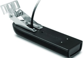
Panoptix™ Ps30 Down Transducer - 010-01284-00 - 322-0100128400F1
With the Panoptix Down transducer, you can actually see fish and bait swimming around under your boat in real time, even while stationary. You get 3 remarkable views: LiveVü Down, RealVü 3-D Down and RealVü 3-D Historical. LIVEVü DOWN: Provides real-time moving sonar images. You can see fish swimming toward or away from the boat. You can see small baitfish and large target fish swimming around, even your lure.REALVü 3-D DOWN: Allows your boat to be stationary and still see things in 3-D around your boat. It shows history of only 1 sweep.REALVü 3-D HISTORICAL: Used for finding fish while your boat is moving. This shows the entire water column you have passed over in 3-D, from the bottom of the surface and all of the fish in between.
Gt8Hw-Tm High Wide Chirp Xdcr - 010-12401-00 - 322-0101240100F1
Perfect for shallow water fishermen who want clear bottom definition under the boat as well as crisp, clear and wide fish arches with excellent target separation. The wider beam width (up to 24°) provides a larger coverage area in the water. The 8-pin transducer features high wide band CHIRP traditional sonar (150-240 kHz) and has a power rating of 250 W. It can be mounted on the transom or a trolling motor. Follow the included installation instructions carefully to avoid damaging your boat.

Gt21-Tm Xdcr 8-Pin Transm Mnt - 010-01962-00 - 322-0100196200F1
Transom mount transducer provides ultra-clear sonar pictures of objects, structure and fish that pass below your boat. This traditional and CHIRP DownVü/SideVü transducer is optimized for depth performance and rough conditions. The CHIRP element has a power rating of 500 W and operating frequencies of 260/455 kHz. The traditional sonar has a power rating of 600 W and operating frequencies of 50/200 kHz. It also includes a built-in fast response temperature sensor.


Gsd™ 25 Premium Chirp Sonar Module - 010-01159-00 - 322-0100115900F1
Designed for the serious sportfisherman, the GSD 25 premium sonar module is a remote network solution that provides outstanding fishfinding and bottom tracking capabilities. It offers true dual-channel 1kW CHIRP allowing you to see two CHIRP frequencies (low, medium, or high) simultaneously, plus DownVü and SideVü scanning sonar with CHIRP technology for the clearest scanning images on the water. It delivers target details so clear and precise, you can actually distinguish between small and closely spaced fish at key fishing depths all the way down to 5,000 ft. Designed for use with the Garmin GPSMAP 8000 Glass Helm series or new GPSMAP 7400/7600 series chartplottters. Frequencies supported include traditional; 50/200, 77/200, 83/200; Single Channel CHIRP: 40-250; Dual Channel CHIRP: 40-250; SideVü/DownVü: CHIRP 455/800 & CHIRP 260/455 (Garmin transducers sold separately)Depth capability to 5,000 feet
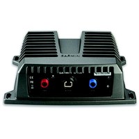
Gsd 24 Remote Sounder Module - 010-00957-00 - 322-0100095700F1
With up to 2,000 Watts of transmit power and a high-dynamic range receiver, the GSD 24 brings high-definition imaging to your compatible Garmin chartplotter. The system is dual frequency (50/200 kHz) capable and offers selectable transmit power (600 W, 1 kW and 2 kW, depending on transducer) for pin-point accuracy at depths of up to 5,000 ft (1,500 m). So whether you're out sportfishing or just keeping an eye on hazardous terrain and reef structures beneath your boat, you'll see a clearer picture with enhanced separation of images and deeper bottom detection. Once connected, your sonar data will be shared on any compatible chartplotter on the network. Plus, the network's high-speed connections ensure that you get ultra-fast screen updates with minimal delay. Features: vastly improved digital sonar design for superior target definition and deep-water performance.
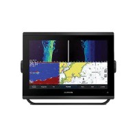
Gpsmap® 723 Non-Sonar With Worldwide Basemap - 010-02365-00 - 322-0100236500F1
With its sleek design, powerful processing and upgraded IPS display, this advanced 7" chartplotter integrates seamlessly into your Garmin marine system. With 60% more display pixels and nearly double the processing power of previous-generation GPSMAP devices, these crisp high-resolution chartplotters integrate seamlessly into your Garmin marine system.Slimline design featuring edge-to-edge glass and a smaller unit footprint, it's easy to retrofit in a wider range of dash configurations.Improved sunlight readability with 60% more pixels than previous-generationGarmin Marine Network, If you have multiple compatible Garmin devices on your boat, you can share information - such as maps, user data, radar and IP camera video - among themNMEA 2000® & NMEA 0183, Connect to compatible autopilots, digital switching, weather, Fusion-Link™ audio system, media, VHF, AIS and more from one screenActiveCaptain® APP, Built-in Wi-Fi® connectivity pairs with the free all-in-one mobile app for access to the OneChart™ feature, smart notifications, software updates, Garmin Helm™ digital switching, Garmin Quickdraw™ Community data and moreIntergrated ANT® Technology, Connect with some of your favorite devices, such as quatix® marine watches, gWind™ Wireless 2 transducers, GNX™ Wind marine instruments and wireless remote controlsJ1939 Connectivity, connect your chartplotter to different kinds of engines, including select Yamaha enginesOneHelm™ Feature, this exclusive feature brings together all the operations and capabilities of select third-party devices, such as EmpirBus™ digital switching, on one screenPanoptix™ Sonar Support, Pair with Panoptix PS51 (transducer sold separately) with FrontVü scanning sonar to help you see and avoid submerged obstacles in real time as you approach within a 300' range


Gms 10 Networking Port Expander - 010-00351-00 - 322-0100035100F1
Connects multiple chartplotters and sensors over the Garmin Marine Network. 100 MB switch, you can connect multiple MFDs and sensors to the Garmin Marine Network and gain the benefit of Ethernet-like data transfer speeds up to 10 times faster than some competitive systems. The GMS 10 and the Garmin Marine Network are completely plug-and-play. Easily expands your system using the same standard data cable to plug additional units and displays into the GMS 10 network ports. Waterproof.
